


1.600
kilometers
This is a social project built on a unique infrastructure. It redefines tourism in Romania, and creates lasting impact for future generations.
The trail has the power to change the way people travel. It offers a new way of valuing rural heritage while helping local communities stay alive and thrive. Via Transilvanica connects nature with cultural identity and strengthens social bonds, turning every step along the trail into a gesture of belonging to a community of travelers.
On the path, every step carries meaning: you discover your own story while also becoming part of the story of the places you pass through.
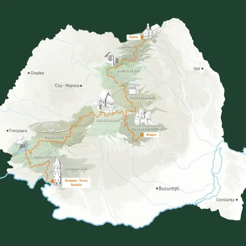
Via Transilvanica crosses Romania from the northeast, starting in Putna, all the way to the southwest, at Drobeta-Turnu Severin and the Danube. The trail passes through 10 counties, divided into 8 cultural-historical regions, covering a total of 1,600 km through diverse natural and cultural landscapes.
In 2025, the trail began expanding, and over the next 20 years, it could reach all of Romania's historic regions.


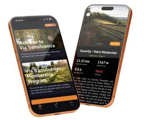
The mobile app is with you every step of the way, whether you're planning your journey or already on the trail. It's easy to use, works offline, and includes detailed maps, stage descriptions, real-time elevation profiles, points of interest, accommodation options, and photos for each section.
More than just a reliable resource, the app connects you to the Via Transilvanica community: track your progress, save favorite spots, and get the latest trail updates. Soon, you'll be able to connect with fellow travelers and share your discoveries along the way.
Designed as a flexible companion, it’s a dynamic tool that keeps your journey safe and makes exploring the trail easier and more enjoyable.
Download the app and start planning your adventure at your own pace!


Best experience in terms of trekking routes. It is a unique chance to meet great people, hosts and travelers, to see great places and get to know Romanian history and culture in a way that will bring joy in your heart like you cannot imagine.

The experience of Via Transilvanica is purely amazing. I have been doing it in sections since 2020, usually in every April and I am richer now in so many ways! I met wonderful people, some of them became friends, and we went back hiking together the next year, too. Via Transilvanica offers a truly authentic and unique experience of what Romania really is! I highly recommend it :)

Via Transilvanica is an experience that will make you appreciate nature, history, and the communities you encounter along the way even more. I walked Terra Siculorum with my wife, and throughout the entire week we filled our souls with unforgettable memories. We will definitely return and continue the trail in stages over the coming years.

An extraordinary way to experience the wild beauty and diverse culture of Romania. I hiked solo, but you can easily meet people along the way. It’s not crowded like other European trails, so you can truly enjoy nature without distractions. Accommodation and food were excellent and reasonably priced. I mostly stayed with locals. It’s easy to plan your trip using the guide available online.

Simply extraordinary! We covered 100 km from Putna to Vatra Dornei in 5 days. The nature, the people, and the views take your breath away. The local hosts are wonderful, and we loved the food they prepared for us. We enjoyed it so much that we continued with another 100 km in the autumn, and we can’t wait to return!

Via Transilvanica is becoming one of the top long-distance trails in Europe. I completed all 1,600 km over the course of three months, and it was one of the most unique trails I’ve ever walked anywhere in the world. You stay with locals, eat food straight from the garden and home-cooked meals, visit monasteries and fortified churches, learn about Romania, and enjoy each unique piece of art on the kilometer stones… There's so much to say. Hike for a day, a week, a month, or more. It’s easy to navigate and to get on the trail. Congratulations, Tășuleasa Social!

Such a great possibility to spend time with family in nature. It’s a unique opportunity to go back in time. Endless trails, fields and sky.

One of those places you’ll keep coming back to. You decide how much time to spend, depending on your availability, fitness, and budget, but nature is already there, waiting… I set off from Putna with my 70-year-old mother, because she wanted to walk this trail in the country where she was born. I’m glad she “convinced” me, and I have to admit I loved every minute of it. The spectacular nature is waiting to be discovered… and the wonderful people are always ready to welcome you with a story.


